
CAN you guess where this week’s Mystery Photograph was taken?
Each week, the Journal invites readers to test their local knowledge by identifying a historic location from the past.
Last week, however, we had a different challenge. Radstock Museum identified this image as local and historic but could not confirm its exact location.
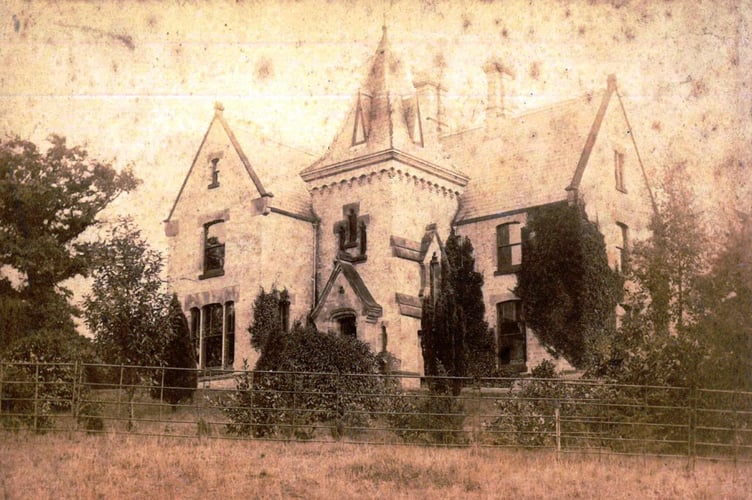


The image is said to be from a location in Somerset but the exact location is still a mystery. The area now known as Somerset has been inhabited since prehistoric times, with evidence of Mesolithic, Neolithic, and Bronze Age settlements. The nearby Mendip Hills were rich in lead, attracting early mining activity. During the Iron Age, hillforts such as Cadbury Castle and Glastonbury Tor were established.
With the Roman invasion of Britain in AD 43, Somerset became an important region, particularly for mining and agriculture. The Fosse Way, a major Roman road, passed through the area, linking Exeter to Lincoln. Bath (Aquae Sulis) became a significant Roman town, famous for its hot springs and the temple dedicated to Sulis Minerva. While Radstock itself does not appear prominently in Roman records, the region saw Roman villas and farming settlements.
After the collapse of Roman rule, Somerset was settled by the Saxons, becoming part of the Kingdom of Wessex. King Alfred the Great, who fought the Vikings from his base in Athelney (near modern-day Bridgwater), played a key role in uniting England. Christianity flourished in the region, with Glastonbury Abbey becoming one of the wealthiest monasteries in England.
Radstock, first mentioned in records from the 13th century, remained a small rural settlement. The town’s name is thought to derive from "red stock," possibly referring to the local iron-rich soil or a Saxon farmstead.
This week’s photo is much closer to home, and we suspect that many of you will find it instantly familiar. The image captures a scene that is deeply connected to our local history, and we’re confident that plenty of our readers will recognise it.