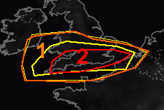
TORNADO warnings have been issued for the south of England as Storm Éowyn looks set to bring disruption to the UK.
The European Storm Forecast Experiment has issued a level two warning across southern parts of the country for severe wind gusts and the potential risk of tornado events on Thursday (January 23) and Friday (January 24).
Storm forecasters have said that “a strong event cannot be ruled out” amid warnings of a main tornado risk along the “Bristol-London” line.
The Met Office has issued red alerts for strong winds in parts of Scotland and Northern Ireland with peak gusts of up to 90mph and 100mph in coastal areas.
Rain and wind warnings are currently in place over the next four days for Somerset and the rest of the UK.
Met Office Deputy Chief Meteorologist Mike Silverstone said: “Storm Éowyn is expected to bring very strong winds and widespread disruption on Friday. There are currently a number of weather warnings in place, with all parts of the UK covered by one warning at some point on Friday.
“Storm Éowyn is expected to cross Northern Ireland early on Friday morning. It will then continue northeast across the northern half of Scotland during Friday afternoon and is expected to be centred near Shetland during Friday evening.
“The strongest wind gusts are likely to be felt across parts of Northern Ireland, southern and central Scotland, northern England and northwest Wales, where exposed sites could get gusts in excess of 80mph, possibly 90mph, which has the potential to cause impacts for those in these areas. The focus for the highest winds shifts to Scotland on Friday night into Saturday.


