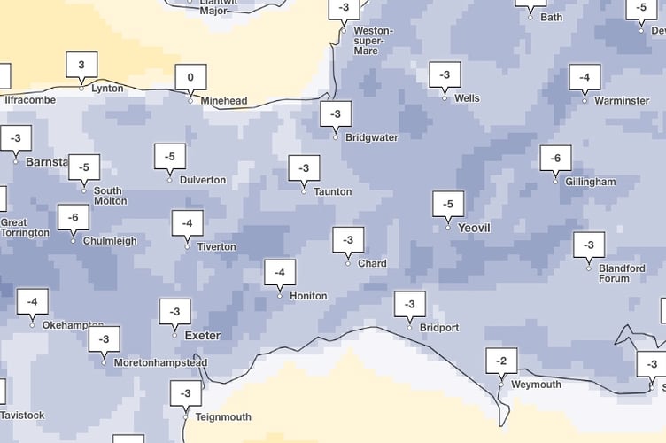
TEMPERATURES could plummet to -7C in parts of Somerset during a cold snap which threatens to dump heavy snow across England over the next few days.
Met Office forecasters have updated a snow warning with ice which is now in place for most of the country between 12pm Saturday and 11.59pm on Sunday (January 5).
The yellow weather warning stretches from Glasgow in the North to the majority of the South of England, with only Cornwall, parts of North West Devon and the Sussex coastline behind spared.
The New Year has begun with a cold spell, bringing wintry showers to parts of the country, but the mercury is expected to drop even further over coming days, with ‘feels like’ temperatures of -7C forecast for Wheddon Cross, Exmoor, and Radstock, early tomorrow morning.
It’s also expected to be chilly in Minehead, with a ‘feels like’ temperature of -5C at around 6pm on Saturday, while temperatures are unlikely to rise much over freezing in Wellington on Saturday morning.

Paul Gundersen, chief Forecaster for the Met Office, said: “Northern parts of the UK are already experiencing colder conditions but by this morning (Thursday, January 2) the much colder air will reach remaining parts of the south and southeast.
“Overnight we have a series of National Severe Weather Warnings in place with a combined yellow warning for both snow and ice for northern Scotland, while a yellow ice warning is in place as far south as the Midlands.
“Standing water remaining from the heavy rainfall of the last few days will freeze, creating a risk for motorists, cyclists and pedestrians navigating untreated surfaces. Wintry showers remain a hazard especially for north-facing coasts and hills.”
Today will be fine and dry for most but it will feel much colder, and this trend will continue into Friday with the threat of overnight ice extending south as far as the South West of England.

Dan Holley, deputy chief forecaster for the Met Office, said: “An Atlantic frontal system is likely to move across parts of central and southern UK through the weekend. With milder, moisture-laden air engaging with the cold conditions already in place this may bring a spell of snow in some areas, before possibly turning back to rain in the south.
“At this stage there is a fair amount of uncertainty over exactly which areas will see disruptive snow, with parts of Wales, northern England and the Midlands most likely to see some impacts. Here we could see 5cm or more in quite a few areas, and perhaps as much as 20-30cm over high ground, including Wales and the Pennines. Coupled with strengthening winds this could lead to drifting, making travelling conditions difficult over higher-level routes in particular.
“We’ve currently issued a Yellow warning for snow covering a large part of England, Wales and southern Scotland to cater for possible disruption over the weekend, but it’s quite likely this will be refined over the coming days as confidence in the forecast increases. So it’s worth keeping up to date with the latest warnings.”


